Everyone hates getting sick but being sick in a foreign country alone can be a whole 'nother level of sick. Matt was getting sick when he moved over into my hotel room and crashed on my bed. I helped Matt get settled into his misery then headed out shortly after noontime for another long climb. Twenty - thirty mile climbs are starting to become old hat . . . good thing because they are not about to stop anytime soon.

I spent the afternoon climbing the dusty dirt road meeting up with the same bus at construction blocks and chatting. I was looking forward to the descent towards Huamachuco but it was not all that pleasant. Occasional baby heads poked up through the powdery dust 10 inches deep piled in the turns and when the road cleared it became a broad washboard.

However, there was a nice lake at the bottom dotted with trout farms but with dusk approaching I had to keep moving. The road was a wash board nightmare that big trucks produce and shortly I realized the source of all the big truck traffic was a local gold mine.

Not so much a singular mine as a collection of small mines slowly taking down the hill. Cars and trucks raised dust clouds choking me to a stop. I was going to welcome the brief stint of pavement leaving Huamacucho when every passing vehicle did not raise a cloud of talcum fine dust.

Huamacucho was a good sized commercial city for the area- so I checked into a hotel just after dark, went to a Polleria (roasted chicken), and looked up Dylan online - who had left Cajabamba earlier in the day. Late the next morning we met in the plaza de armas, went to the market to buy some coca, and left town.

We enjoyed the brief stint of pavement knowing it would be our last for the next week or so. The road climbed steadily going over 4000 meters - high enough for trees to disappear and the landscape goes to puna. Puna is the starkly beautiful high grassland that characterizes the central Andes of Peru. Cold but not high enough to snow - though we did get lightly hailed on climbing the pass - just enough to spice things up and remind me of where I was going.

Once we topped out on the plateau we were looking for a dirt road heading south to the town of San Simon. Roads signs are typically absent so I relied more on "its headed in the right direction" form of navigation - along with asking anyone who might me around.

We turned off onto a rough loose dirt road towards the town of San Simon. We could have camped but our maps were starting to lack utility and we needed to ask directions to find our way. San Simon was more gold mine than town but after asking at the mine entrance we located the small community and a room to stay in.

Electricity did not come on until 7pm and then there was not much of it - to walk on the road required a headlamp. But the mine was lit up like Times Square . . . makes you wonder what the community gets out of this monstrous mine. Evidently not much electricity, certainly no sanitation or clean drinking water, (el bano is a shallow hole screened with a blue tarp) some jobs, no gold. Meanwhile they live next to a huge internationally owned strip mine that poisons everything downstream.

We backtracked out of town 5km to go left at the cemetery and begin climbing towards the community of Angasmarca. Our maps are now officially useless but they provide us with names of communities and generally enough people are around to ask. However, most people do not have a vehicle . . . which presents another set of difficulties. We are usually told about bus routes and everything is lejos (far) or lejitos (a little far).

Truckers are a great source of directions and we run into some loading up with coal to run to Trujillo, which they did about three times a week. The coal mines dotting the region are all locally run. The building is the mine owners and the trailer is a days worth if mining. All work is done by hand mining to loading the trailer.


The drivers were sitting while the truck was loaded and immediately recommend that we drop down another road that goes directly to Angasmarca thereby saving ourselves a big climbing loop.


The road is crazy steep and narrow passing more small coal mines. No one previously mentioned this route because it is pretty much impassably to cars and forget busses. It is not so much a road as a collection of roads winding across the hillsides. Directions are now a broad hand wave indicating direction along with something equally vague like "todo directo." But the terrain is immense so once we figure out the valley to Angasmarca we simply head in the right direction on rough dirt roads passing more small independent mining operations and an Inca ruin overlooking the entire valley.

All along the ride people asked if we were going to Angasmarca for the fiesta? Less than an hour outside of Angasmarca we meet a group of utility workers on break (lots of poles but no lines yet). They call us over and we sit for an hour chewing coca and chatting. Besides the usually questions about our travels, then living and working in the United States, we get filled in on the fiesta we are riding into - over 4 days of 12 bands, dancing, bullfights, cock fights, 100 bulls running loose in the streets. Riding into Angasmarca we hear a brass band belting out dance tunes, people are dancing in the streets spraying beer in the air, and the cows are dressed up in balloons and ribbons . . . you are in trouble when the cows are dressed to party. . . shortly we are standing in a circle drinking Andean style still in bike regalia.

 I spent the afternoon climbing the dusty dirt road meeting up with the same bus at construction blocks and chatting. I was looking forward to the descent towards Huamachuco but it was not all that pleasant. Occasional baby heads poked up through the powdery dust 10 inches deep piled in the turns and when the road cleared it became a broad washboard.
 However, there was a nice lake at the bottom dotted with trout farms but with dusk approaching I had to keep moving. The road was a wash board nightmare that big trucks produce and shortly I realized the source of all the big truck traffic was a local gold mine.
 Not so much a singular mine as a collection of small mines slowly taking down the hill. Cars and trucks raised dust clouds choking me to a stop. I was going to welcome the brief stint of pavement leaving Huamacucho when every passing vehicle did not raise a cloud of talcum fine dust.
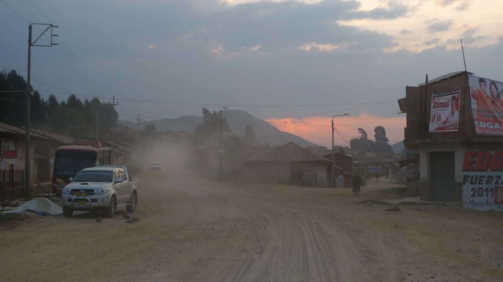 Huamacucho was a good sized commercial city for the area- so I checked into a hotel just after dark, went to a Polleria (roasted chicken), and looked up Dylan online - who had left Cajabamba earlier in the day. Late the next morning we met in the plaza de armas, went to the market to buy some coca, and left town.
 We enjoyed the brief stint of pavement knowing it would be our last for the next week or so. The road climbed steadily going over 4000 meters - high enough for trees to disappear and the landscape goes to puna. Puna is the starkly beautiful high grassland that characterizes the central Andes of Peru. Cold but not high enough to snow - though we did get lightly hailed on climbing the pass - just enough to spice things up and remind me of where I was going.
 Once we topped out on the plateau we were looking for a dirt road heading south to the town of San Simon. Roads signs are typically absent so I relied more on "its headed in the right direction" form of navigation - along with asking anyone who might me around.
  We turned off onto a rough loose dirt road towards the town of San Simon. We could have camped but our maps were starting to lack utility and we needed to ask directions to find our way. San Simon was more gold mine than town but after asking at the mine entrance we located the small community and a room to stay in.
  Electricity did not come on until 7pm and then there was not much of it - to walk on the road required a headlamp. But the mine was lit up like Times Square . . . makes you wonder what the community gets out of this monstrous mine. Evidently not much electricity, certainly no sanitation or clean drinking water, (el bano is a shallow hole screened with a blue tarp) some jobs, no gold. Meanwhile they live next to a huge internationally owned strip mine that poisons everything downstream.
  We backtracked out of town 5km to go left at the cemetery and begin climbing towards the community of Angasmarca. Our maps are now officially useless but they provide us with names of communities and generally enough people are around to ask. However, most people do not have a vehicle . . . which presents another set of difficulties. We are usually told about bus routes and everything is lejos (far) or lejitos (a little far).
 Truckers are a great source of directions and we run into some loading up with coal to run to Trujillo, which they did about three times a week. The coal mines dotting the region are all locally run. The building is the mine owners and the trailer is a days worth if mining. All work is done by hand mining to loading the trailer.
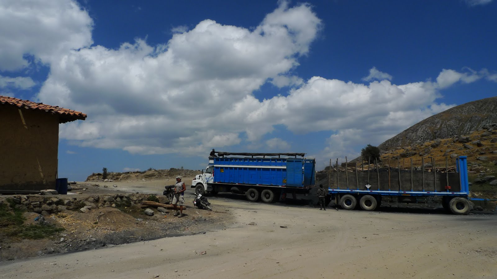
 The drivers were sitting while the truck was loaded and immediately recommend that we drop down another road that goes directly to Angasmarca thereby saving ourselves a big climbing loop.
 The road is crazy steep and narrow passing more small coal mines. No one previously mentioned this route because it is pretty much impassably to cars and forget busses. It is not so much a road as a collection of roads winding across the hillsides. Directions are now a broad hand wave indicating direction along with something equally vague like "todo directo." But the terrain is immense so once we figure out the valley to Angasmarca we simply head in the right direction on rough dirt roads passing more small independent mining operations and an Inca ruin overlooking the entire valley.
 All along the ride people asked if we were going to Angasmarca for the fiesta? Less than an hour outside of Angasmarca we meet a group of utility workers on break (lots of poles but no lines yet). They call us over and we sit for an hour chewing coca and chatting. Besides the usually questions about our travels, then living and working in the United States, we get filled in on the fiesta we are riding into - over 4 days of 12 bands, dancing, bullfights, cock fights, 100 bulls running loose in the streets. Riding into Angasmarca we hear a brass band belting out dance tunes, people are dancing in the streets spraying beer in the air, and the cows are dressed up in balloons and ribbons . . . you are in trouble when the cows are dressed to party. . . shortly we are standing in a circle drinking Andean style still in bike regalia.

No comments:
Post a Comment